在 python 的 netCDF 文件中提取特定纬度/经度的传感日期/时间
我目前正在使用 python 处理多个 netCDF 文件。我在大伦敦上空使用 Sentinel-5P NO2 对流层柱。我想将各个文件绘制为一个时间序列,标题为每个单独条带的伦敦逾越节时间,但我不确定如何提取它。
有没有一种简单的方法可以为每个文件提取卫星在特定纬度/经度上的逾越节时间?
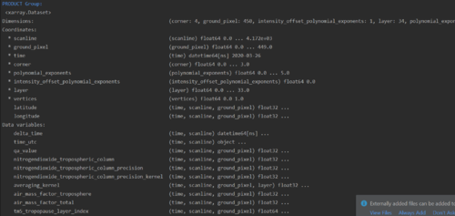
编辑:关于文件的更多信息。它们是 netCDF 文件,意味着它们包含维度、变量、属性和坐标。它们包含有关伦敦上空 NO2 垂直柱密度的信息,空间分辨率为 3.5x7km。我已经在 PyCharm 中使用 xarray 打开了文件,并进一步附上了一张图片以提供有关变量的更多信息。

当 latitude=51.2 或 51.8 时,我基本上需要找到 delta_time 的值。以下是我到目前为止开发的内容,但是我有大约 50 个文件都超过 100,000 像素,所以这非常非常慢。有谁知道我该如何改进?
for i in file_list:
# Open product - GROUP PRODUCT
with xr.open_dataset(i, group='PRODUCT') as file:
print(colored('\nPRODUCT Group:\n', 'blue'), file)
no2 = file['nitrogendioxide_tropospheric_column'][0]
for row in no2.coords['latitude']:
for cell in row:
if cell == 51.2 or cell == 51.8:
print(cell)
print(cell['scanline'])
scanpoint = (cell['scanline'])
scantime = no2['delta_time'].sel(scanline=scanpoint)
print(scantime)
return scantime
else:
continue
 largeQ
1回答
-

蓝山帝景
你应该能够使用向量化的 NumPy 函数来做你想做的事。现在,我不太确定比较浮点数的相等性,但这应该与你的相似。我没有专门使用 xarray 但使用过 netCDF4,所以它说<array>我的意思是为该变量/坐标获取一个 numpy(或等效)数组。另外,请注意,我没有选择一个单独的时间值,它看起来像你有,但我只是使用latitudes 的整个 3D 数组。import numpy as nplatitude = <3D latitudes array>delta_time = <2D delta_time array># 3D boolean array with our required conditioncondition = (latitude == 51.2) | (latitude == 51.8)# Expand tuple of indices, one for each of the 3 dims, but ignore ground_pixel dim# Each of these idx arrays is 1Dtime_idx, scanline_idx, _ = condition.nonzero()# Get 1D array of delta_times by using time and scanline indicesdelta_times = delta_time[time_idx, scanline_idx]这应该为您留下所有三个维度中所有相关单元格的坐标 ( condition.nonzero()),以及delta_times这些单元格的坐标。no2请注意,如果您不使用实际值并且只关心latitude和,则不需要实际数组delta_time,但您始终可以使用 之类的方法获取相关单元格的值no2[condition]。
 随时随地看视频慕课网APP
相关分类

 Python